The Collins family is one of the oldest Melungeon families to have settled in the Kyles Ford area. Collin's Melungeon Star represents the deep family history and Melungeon heritage that makes this area so unique.
Greene's barn majestically adorns the graceful rolling hills of Greene's cattle farm in the heart of Melungeon country. Cattle's not all you'll find; stop in to see the sugar cane grow and buy some homemade molasses.
{ waypoint }
CONTACT INFORMATION
Intersection of Hwy 66 & Don Green Rd
Sneedville, Tennessee
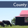
Discover the beauty and majesty of old-time cattle farming along the river at Ramsey's farm in historic Sneeville. Find local shops, great spots for lunch and a long road for Sunday driving that leads to Kyles Ford, one of the oldest settlements in Tennessee.
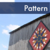
The beautiful barn at Antrican's farm is adorned by the Harvest Star. Stay awhile and explore the beauty of the Cantwell Valley or Clinch Mountain.
Antrican's barn, located on a working cattle and hay farm, is a beautiful backdrop for the Harvest Star and represents a way of life in Cantwell Valley little known in today's fast pace world.
The Clinch-Powell Community Kitchen is a working food processing and packaging facility in the rural community that assists local farmers and producers package their food and food products for purchase. This assistance is a community development project of the Clinch-Powell RC & D.
The Clinch-Powell Community Kitchen is a rural economic development project to assist local farmers and individuals with a resources for packaging and preparing food products for market. Tours are available.
Kyle's Ford, one of the most biologically diverse regions of the world, is home to the historic Bledsoe homestead. Slow down and enjoy the drive across the mountain to this historic place and enjoy the Flying Star when you get here.
The Bledsoe Farm is an original Kyle's Ford settlement and has seen generations of history, from the building of the Melungeon community, to the many battles of the Civil War fought in the region. The Bledsoe barn is adorned by the Flying Star.
The Inlay Star on Ramsey's barn is befitting a full-time working farm. The Ramsey family farm produces cattle, tobacco and hay in the heart of Appalachia.


.JPG)
.JPG)
.JPG)
.JPG)
.JPG)